Wednesday, January 16, 2013

Goree: of Slavery, Signares and Foreigners with Cash

Dofokow in the Mande languages of West Africa translates to English as "history matters", or historical topics. This is an occasional blog about travels through Senegal, Guinea and Mali conducting research for my dissertation on the history of cloth during the period of Atlantic slave trade.

Goree Island, Senegal West Africa


Two of the hottest Hollywood films out right now deal with American slavery, "Lincoln" and "Django Unchained." The history of slavery in the United State is once again in mainstream cultural vogue, this time with A-list directors Stephen Spielberg and Quentin Tarantino putting this difficult subject before popular audiences in new ways.

So it was an interesting time to visit Goree Island, off the coast of Dakar, Senegal. The small volcanic formation off the western tip of Senegal (Dakar's skyline is clearly visible from the island) was unoccupied when Portuguese traders first came there in the 15th century, using it as a base from which to trade in gold with Africans, but then becoming the first among many Europeans after them to focus on trading slaves.

The settled part of Goree Island is so small you can walk leisurely around it in two hours or so. The biggest chunk of the tourist crowd that travels over daily by ferry from Dakar do just that before returning the same day. Every day. Like clock work. Beginning with the first ferry crosses over about 10:30, ferries arrive every two hours dumping groups of FWC ("Foreigners With Cash") onto the island famously associated with the Atlantic slave trade--although historians say the island played only a small role, contrary to popular belief.


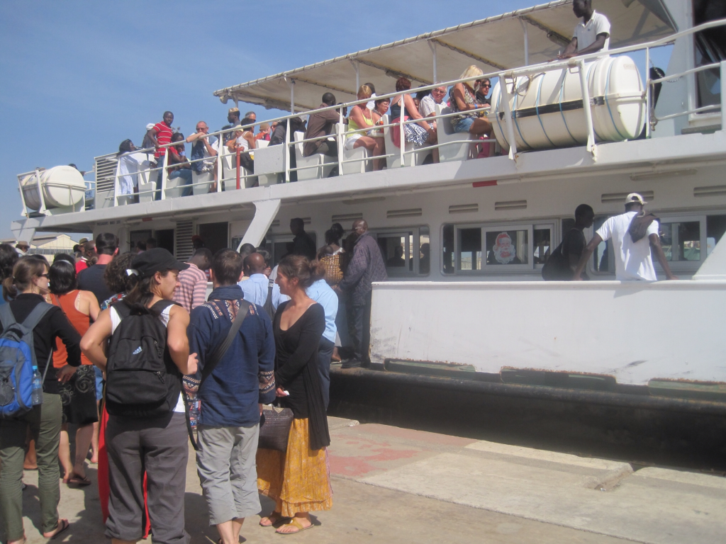
Not only foreign tourists take the ferry, of course. Most travelers are Africans, including a few Senegalese and other African tourists and visitors. Many of the Africans are coming to visit family and friends while others come to work for the day in some tourism related way. Like the guy in the Orlando Magic cap who entertained the crowd on the ferry I rode over a few days ago.

Got Maracas?

He was all smiles and joy on board as he sang improvised songs about, among others, Cheikh Amadou Bamba, accompanied by a pair of local maracas. Not clear at all that the group of young Italian tourists who happily joined in the music making realized they were partying in praise of the founder of the Mourides, an Islamic Brotherhood. But hey, does it really matter? It was a fun way to pass the time. And the singer was selling those maracas (prices starting at 5,000 CFA/ $10, for the gullible and loaded).

Dear reader, before going further, it must be said that here in Africa, your blogger is a FWC too. No matter my actual purpose in coming, for now, I am but one tourist among many. The woman at the port in Dakar from whom I bought my ticket was surprised to discover that I am an American, a foreigner. She said, "Mais, you seem like an African!"

"It's a long story," I joked, moving past her into the large, crowded waiting room where people in straw hats were posing for pictures in front of a large, fake Santa Claus. After four years of intermittent trips to Africa, I have gotten used to a range of African responses to myself as an African American traveler, from "you must be one of us!" to, more frequently, "you cannot possibly be one of us! Where are you from?" I have learned to take none of it too seriously. It is what happens when you leave home to another part of the world: people are genuinely surprised to see you and they are not quite sure what to make of what they see.

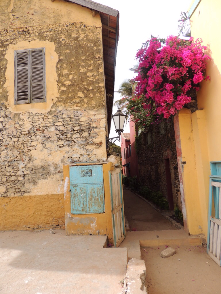
Like everyone else on the ferry, I paid my 10 dollars and took the short ride here just a quick sense of the place. Once ashore, I made the rounds. In a couple of hours, I had walked from end of the island to the other: through the informative IFAN museum housed in a circular fort, through a quiet maze of dusty streets and old French colonial homes

Is this Africa? Or a village in France?
 
Is this Africa? Or a village in France?

and up a slope where vendors were selling hastily-made paintings, beaded jewelry, and trinkets. Here on Goree it is not easy to slip out of the structured role of an FWC--at least not right away. I felt like fresh fish swimming through a pond of hooks. "Bonjour! Ca va bien? Venez voir ma boutique! Come see my boutique! Nice price for you! C'est pas trop cher! Ok, Maybe later!"

Or, my favorite line from some local children, guileless, direct: "tsssst! Hey, Mister! Gimme some money!"

Things were no different by the time I reached La Maison des Esclaves (House of Slaves) home to the iconic "Door of No Return". There were some men (no women) standing around outside trying to make some money as "guides." Some had ID cards saying they were officially sanctioned and trained. As I approached I saw a tall guide leaving with an older European couple, having just been inside. I heard the woman say to the guide in heavily accented English, "but, I am glad tings ahv changed now! Daht slay-vah-ry is no more." The guide did not understand her. She tried again, "I mean you, for example, you are not a slave!" I did not hear the guide's response as they walked away. But even I winced.

Inside, the house and grounds were smaller than I expected (although upon reflection, I should have remembered the many 18th and even 17th century homes I have entered in my native Philadelphia). Once through a small vestibule, I was standing right in front of the curved staircases leading to the upstairs quarters and could look straight ahead through the lower portion of the building which housed slaves in a number of rooms beneath the staircase. At the very end of a darkened passageway was the rectangular opening to the blue sea.

FWCs hang out at the Pepin family home, now known as la Maison des Esclaves
Upstairs full of light and refreshing sea breezes; downstairs dark and stuffy. Get it?
 
A local guide helps to explain the site to a tourist

There is still much about this house in particular, and the island in general, that I am still learning. But the "Maison des Esclaves" appears to have been owned by Anne Pepin, a Senegalese signare, one of a wealthy class of mulatto women who were critical to business transactions between Africans and Europeans throughout this part of the African coast. (In other words, according to some American black nationalist interpretations, and the old fashioned American racial logic of the "one-drop" rule, I was basically standing in the foyer of a black woman's house!) It is still unclear who built the house (help me out if you know) whether it was Anne and her husband, or her brother Nicholas. Anne was reportedly the lover to the island's French governor in the late 18th century, Chevalier de Boufflers, to the apparent humiliation of his wife, Ann Sabran. It was Anne Pepin's niece, Anna Cola, who is depicted (in the lower left, wearing the white shawl) in an image of the home in 1839 about a generation after Anne Pepin lived.


Usually, the offspring of European men and African women, signares typically became the "local wives" of European traders who were valued for their family connections to local Africans as well as their facility with European language, culture and entree into the transient European society. Signares were frequently slave traders, slave owners and active in any number of other lucrative trades such as the trades in gum Arabic, in cloth and other commodities. Because of their wealth and location within a web of gendered, racialized social and economic relations, signares (from the Portuguese 'senhora' or 'lady') were often the figurative and literal "belles of the Ball," on Goree. In coastal settlements from the Senegal river to Freetown, Sierra Leone, they were key figures in trade between Africans and Europeans. Tastemakers, they are often represented in drawings and paintings from the period draped in varied and expensive fabrics and jewelry.

Where exactly did Ann Pepin and her house fit into this generalized picture, I don't yet know. It was apparently the activism of Boubacar Joseph Ndiaye, a Senegalese decorated veteran of World War II, that over time drew more international attention to Goree and to this house as a major site in the history of slave trade. A number of historians have since poked major holes in the assertion that the house was a major trans-shipment point for "millions" of slaves from Africa to the New World. This is not to deny the importance of the trade in slaves from Senegambia over four centuries or its many related horrors, but rather to insist on accuracy, clear-eyed analysis and credibility over sentimentalizing, moralistic posturing and opportunism.

Beyond that controversy, what role does the memory of African slavery play among the publics in Africa, Europe and the Americas? It is a question that US American audiences who see either of those two popular films now are freshly confronting. Both films focus tightly on the 19th century American national story, foreclosing consideration of the much longer historical period of Atlantic slaving, much less of the view from Africa. They seem only interested in constructing and reconstructing a kind of national US story. But as more African governments turn to tourism as a vital source of foreign cash, to what extent and in what ways will they continue to make use of the numerous sites along thousands of miles of coastline that testify to the trade? What national and international stories are being constructed in these sites? Which stories are being occluded and silenced? And how does the potential flow of FWCs to these sites affect the choices made?

Where do the stories of inter-racial slave trading couples, of "black" and mixed race women slave traders, of African kings, porters, canoemen, farmers and cooks as "agents" of the slave trade, along with those of European male traders, sailors and adventure seekers, and yes, the millions of enslaved people, fit into popular, touristic narratives of that period of world history?

What do you see?


Sunday, March 4, 2012

Difference in the city -- Maps and 19th century Newspaper Accounts

View of the Fisherman's quarter on Guet N'Dar (part of St. Louis du Senegal) Source: Saint-Louis du Senegal d'hier a aujourd'hui by Abdoul Hadir Aidara

       In March 1855, a short item published in the Detroit Daily Free Press quoted a description of Saint-Louis du Senegal from an American sea captain who visited the island settlement more than four decades earlier in 1810. “On approaching the place all appears enchantment, to behold such monuments of human industry rising amid a barren waste of sands,’’ the captain, unfortunately unidentified, is reported to have said. 
       He continued: “Vessels anchor abreast of the fort, half a league off shore, and the only way to pass through the tremendous surf is by native boats. The town is on a small island of sand, scarcely above the level of the tide and in heavy freshets is often inundated….The town of Senegal is about a mile long and a half a mile wide—houses large and convenient, mostly of stone and brick. At present (1810) the richest inhabitants are blacks, two of whom are worth over $100,000 each. The fort is large, and of sufficient extent to contain all the inhabitants in case of invasion by the natives.”
       This description is interesting from a number of perspectives. It reminds us, first of all, that the original French settlement of St. Louis was limited to the narrow island that lay in the midst of the Senegal river, itself bounded to the west by a sandy peninsula extending south from Mauritania and on the east by the African mainland. The relative isolation of this unoccupied island and the difficulty of access to it were initially selling points for the French settlers because these geographic features made the space easier to protect from European and African competitors. But as the passage indicates the town was always vulnerable to flooding. Throughout the 19th century, as ships became larger and economic contexts changed, the rough surf and sandbars around St. Louis slowed down commerce, prompting the emergence of Dakar, which had better harbors. 
       The description also mentions housing. Probably, the speaker is referring only to the French-built houses on the island, although sketches of the town indicate that African thatched structures were integrated into the town as well. 
        Finally, the speaker describes what might be called the “social geography” of St. Louis du Senegal at the time. First, he refers to the relative wealth of the town in the 19th century, asserting that African wealth was more important than that of the French. This statement about Senegal by an American observer and published in an American newspaper must have lent the story an “exotic”-man-bites-dog feeling in that it inverted conventional racial hierarchy. All the more so, because of the lack of specifics…Also, his comments create a binary distinction between “inhabitants” and “natives”, suggesting that one needed to be protected from the other… 

1847 map of Saint Louis du Senegal. Source: Saint Louis du Senegal d'hier a aujourd'hui by Abdoul Hadir Aidara
This map presents an image of the layout of the town around the time that the newspaper article appeared. Stay tuned for a comparison between this image and a contemporary map of the city. For now, though, it is noteworthy that the island is depicted with grid-like streets on either side of the central fort (and Catholic church). Across the river to the west, the peninsula is shown as uninhabited except for a "village of Negros" according to the map maker, called Guet N'Dar. This is roughly the location of the neighborhood of that name on the peninsula today.


1868 map of Segou-Sikoro on the Niger river
         Newspaper accounts in English of Segu are a bit more scattered, but in a quick scan I noticed that Segu is referred to as a “sacred city” and a “religious centre.” In April 1890, the New York Tribune ran a story describing the French conquest of Segou with the following headline: “Capture of Segou Town—King Ahmadou’s Country Raided—Halfway Station to Timbuctoo”. The headline states rather clearly where Segu lay in the French geographical imagination of the region, with the desert-side trading and scholarly town of Timbuktu retaining its centuries old allure. At the time, the French sought to control commercial connections between the Upper Senegal river valley and the Upper Niger river valley (and ultimately to Algeria on the North African coast). Segu is described as “a strongly fortified town situated on the left bank of the Niger.”
        The 1890 French conquest of Segu was actually the second time in 30 years that the settlement on the banks of the Niger river that was the center of an expansive polity, had been conquered. In the 1860s, the non-Muslim Bamana rulers fell to the forces of the Fulani Muslim cleric Umar Tall, an event that was reportedly celebrated as far away as Fez and Cairo as it signalled the defeat of a major “pagan” power. It was the son of Umar Tall, Ahmadou, who the French in turn defeated, carrying away “the royal treasure” and members of his family.
         In an indication of the times, the article is full of ethnocentric rhetoric that belittles the Umarian polity designed to build public support for imperial intervention in Africa. It describes Umar Tall’s supporters as having “no other occupation but that of waylaying and murdering travellers, as they did lately with the Flathers expedition.” It concludes, “The fact is that the capture of Segou deals a terrible blow to the predominance of the murderous Toucouleurs, whose warlike fanaticism offered the greatest obstacle to the extension of the civilizing influence of Europe in the Soudan.”

Sunday, February 26, 2012

How are Saint-Louis du Senegal and Segu, Mali represented on the Web?


Saint-Louis du Senegal Aerial view


Do a quick search of Saint Louis du Senegal or of Segu, Mali and you will mostly come up with a number of websites geared toward promoting the cities as tourist destinations. I've posted a few choice examples throughout this blog (please enjoy! and let me know if you know of others).

Each city boasts an international festival of music. Saint Louis holds an international jazz festival in May or June and each February http://www.saintlouisjazz.com/, Segu holds Le Festival sur le Niger http://festivalsegou.org/new/en.html that features big names in Malian and West African music. Beyond music, websites in English and French generally showcase historical and cultural aspects of life in each of these West African cities. Websites posted and maintained by local residents such as youth groups, religious organizations or business groups can be harder to come by.

Saint Louis du Senegal http://www.saintlouisdusenegal.com/ maintains a fairly slick web presence that features tourism information along with general local news items, stories about the environment (such as a feature on the white pelicans of the wetlands in nearby Djoudj National Park), political campaign advertisements (Senegal is holding a hotly contested election on Sunday, Feb. 26) and real estate listings. 
The tourism aspects of the site emphasize its designation as a UNESCO World Heritage Site http://whc.unesco.org/en/list/956; the city based on a narrow island in the Senegal river having once been a base for French colonial ambitions in West Africa.   

Here’s a cool video tour of the city by a French-speaking journalist. If you don’t understand French, it still gives a good feel for the place.


One interesting aspect of St. Louis’ cultural history is the annual parade of the Fanal each December; a centuries old tradition that is said to have begun with the signares, wealthy, often mixed-race female merchants. The tradition reportedly began with a procession of these wealthy women to Catholic mass at midnight on Christmas Eve, preceded by one or more porters carrying lanterns. For local spectators, it gradually became a question of who had the most abundant, colorful and large lantern displays. Over the years some of the “lanterns” became large, colorfully decorated float-like constructions of wood, light, and brightly colored-paper as much as 16 feet tall! And of course, it was always a bit of a fashion show, in which each signare displayed her fancy clothes for the occassion. 

A group of Saint Louisiennes celebrating Fanal. from saintlouisdusenegal.com

As mentioned in an earlier post, what today is the city of Saint Louis du Senegal began as a formerly uninhabited island where the French built a fort in 1659.  In looking at the map of Saint Louis, it appears that the government building is located in the same general spot where the French trading fort once stood. Facing it is the Catholic church, which is naturally a focus of the Fanal cultural procession in December. In traveling onto the island from the mainland, these would be the first two buildings drivers, cyclists and pedestrians would pass.


Segu


Le Festival sur le Niger has become the focus of an effort of local leaders to make Segu a major cultural destination for foreign and national visitors—as well as an important boost to the local economy. The festival takes place on the first weekend in February (the 2012 event just happened but I have as yet had up to the minute reports!) and features lots of music, film, theater and dance. http://festivalsegou.org/new/en.html
The work that the festival does in February in raising the profile of Malian culture continues all year round through the Centre Culturel Kore, a recently opened local arts institution that holds educational and cultural events throughout the year. A link to their website can be found on the Festival on the Niger website. Open to the Segovian public, the Centre Culturel Kore invites local authors, scholars and griots to make presentations on aspects of the city’s history. 

Segu is the birthplace of a few well known Malians, including Adame Ba Konare, historian and former First Lady of the country (she is the wife of Alpha Umar Konare who served as president from 1992-2002) and Bassekou Kouyate, an internationally celebrated player of the ngoni, a traditional Malian string instrument. Ba Konare is a well-known activist on behalf of Malian women and created one of the few museums dedicated to women’s history in West Africa. It is located in Bamako. http://www.museedelafemme.com/presidente.html

Headquarters for Groupe Kasobane in Segu. It's made of "banco" local mud in a style resonant of regional history


The building's architectural style incorporates designs that also appear in Bamana textiles and in wooden masks. It is located in a very visible location aside a national highway from Segu to Mopti
In recent years, Segu has also been growing in importance as a producer of Mali’s famous “mudcloth” or bogolan, as it is known in  the Bamana language. Segu is not traditionally the home of “authentic” bogolan, whose uses have been deeply involved in aspects of Bamana lived culture. However, a couple of innovative studios have appeared that produce contemporary design versions of the cotton cloth that is colored using an acidic clay.   These studios Group Kasobane http://www.africancrafts.com/artist.php?id=groupekasobane and Soroble, located at opposite ends of the city, teach the craft to young workers and well as expose tourists to the traditional dyeing and cloth-making techniques of the region. 
Here is a map of one of the sites.


And a picture of another Bogolan factory Soroble located on the banks of the Niger river. Both Soroble and Groupe Kasobane employ local artisans in creating contemporary textiles using traditional dyeing techniques from the region, thereby adding to the economy and giving old traditions new life. 

The entrance to the Soroble bogolan factory, also constructed in "banco" and located on the banks of the river Niger. 


Sunday, February 12, 2012

Saint Louis and Segou (Sikoro): Broad Historical Sketches

Saint, Louis, Senegal


Today Saint Louis is a UNESCO World Heritage site celebrated for its faded, but elegant French colonial architecture.
       The oldest French colonial settlement in western Africa sits on the end of a long narrow peninsula extending south from Mauritania. The peninsula appears on some maps as the "langue de Barbarie" (literally "the tongue of Barbary"). The coastal region had been visited by traders from Portugal beginning in the 15th century, followed by those from Holland and England in the 16th century. But it was the French who first settled on nearby Bocos island in 1638. Because of repeated flooding there, the French moved about 25 km away to the current settled on the peninsula where they built a fort in 1659.

The fort at Saint-Louis around 1780. Notice the thatched-roofed buildings nearby. There is a range of architectural styles in this depiction.


Wolof speakers referred to the land as N'Dar ("island"). One source said that local people did not settle on the island because they believed it to be inhabited by spirits. Nevertheless, a local notable, the Diagne of Sor, allowed the French to settle there in exchange for an annual customary payment of "three pieces of blue cloth, a measure of scarlet cloth, seven long iron bars and 10 pints of 'eau de vie'.” (Biondi, 37)

The peninsula settlement enjoyed natural protections on all sides from surprise attack including rough surf at the mouth of the river. As the staging ground for trade with the African interior upriver, the settlement attracted a growing population of boatmen (laptots), fisherman, traders and a burgeoning "metis" or mixed race population.

 Some sources say that the French named the settlement for King Louis XIV (1638-1715), the Bourbon monarch known as the Sun King, who took power in 1661. However, other sources note that the name actually honors the Sun King's patron saint, an earlier King Louis IX (1214-1270) who is the only French monarch to have been canonized. Interestingly, Louis IX led two Crusades against Islam in Africa, one in Egypt and the other near Tunis, both of which ultimately failed. Louis IX was member of the Trinitarian religious order that dedicated itself to redeeming Christians held captives by non-Christians. He died in North Africa in 1270 but he is remembered by Catholic faithful as a "selfless warrior for Christ." (Encyclopedia Britannica)

Several colonial settlements in the Americas and Asia from this early period and later periods are named for Saint Louis including San Luis Potosi in Mexico, St. Louis, Missouri (formerly French territory), Sao Luis do Maranhao in Brazil, lake Saint Louis in Canada and rue Saint Louis in the former French colony of Pondicherry, India.

But for Saint Louis, Senegal, biographical details of its namesake and the questions of slavery and religious conflict seem to resonate with the later history of this French settlement, as well as that of the broader region.

Perhaps not coincidentally, 1659 was also the year the French officially established a colony on the mainland of Saint Domingue (later Haiti) in the Caribbean. Other islands that the French already occupied in the eastern Caribbean (St. Christopher, Guadeloupe, Martinique) were being supplied with African slave labor by the Dutch. The settlement at Saint Louis was thus if not the first then part of an early effort for French companies to supply the French Caribbean islands with enslaved labor.


Negress of quality from the Island of Saint Louis in Senegal, accompanied by her slave, Illustration from Costumes civils actuels de tous les peuples connus, Paris, 1788, by Jacques Grasset de Saint-Sauveur.
        A community of African and metis (racially-mixed) residents were key to trade interactions throughout the region.  For example, African-born women known as "signares" from the Portuguese word "senhoras," became key to the process of intercultural trade in Saint Louis and on Goree island. Sometimes they were referred to as "gros bonets" for the large and colorful turbans they frequently wore. These women frequently were the wives of traveling French merchants who spoke local languages and helped establish trade linkages. When their husbands left the island or died, they inherited wealth. Also, key among the African residents were "laptots" who were local canoemen and servants who facilitated trade.


      Here is a view of Saint Louis from above. The area of the original seaside settlement appears distinctive from this view:


Now a bit about Segou (Sikoro). 

Street scene in Segou 

Located far inland, in the middle Niger river Valley, Segou's eighteenth century trajectory is related to Saint Louis in ways that I am still trying to better understand. The Bamana-speaking peoples who live there were formerly part of the much larger Mali empire that began in the 13th century and flourished until about the 15th century. Here is a snapshot of the region circa the 14th century.


      The large orange shape shows the approximate reach of Mali in the 14th century. But not represented here is that the authority of its rulers stretched at its peak to the Atlantic coast and included the territories of the Wolof (and what became Saint Louis). Mali had grown on the relative strength of its trans-Saharan trade in gold, slaves and other commodities. Not only material goods but ideas, books, technology and religion also circulated across this vast space linking this part of Africa to developments in southern Spain, for example, as well as to Tunis, Cairo, Baghdad and perhaps beyond.

The fall of Mali is perhaps related to a number of factors including shifts eastward in trans-Saharan traffic, favoring Songhay and Hausa-speaking areas, internal disputes over succession and the rise of trade on the Atlantic coast that dissipated the empire's hold over peoples with new potential sources of income from trade.

The 18th century founding of Segou is surrounded in mythical legend. There is some disagreement about its original name which some say was Sikoro (Bamana for "under the shea tree") and others say was "Sekou" the name of a Koranic student who studied there. One source notes that the settlement was founded by Bozo fisherman. The question of the naming indicates the many interactions that the region has interacted with Islam and Islamization over the longue duree.

That said, many historians agree that what became the state of Segu was started around 1712 by Mamari Koulibaly, a hunter of low birth who, together with young men of his age, staged a generational revolt against local rulers. The Bamana are agriculturalists who grow millet, sorghum and other cereals. The state grew quickly on the Koulibaly's military strength and wealth gained from raiding for slaves that were sold across the Sahara and to ports on the Atlantic coast. By the 1840s, Segu's power stretched far across the savanna, but so to was the power of the French encroaching for their original hold on Saint Louis.


In between the two forces, were settlements of Fulani pastoralists at Futa Toro, Futa Djallon, Bundu and at Macina. They would become important to events in the 19th century as an Islamist reform movement swept the region impacting both the fate of Segu (which fell to the Fulani jihadist Umar Tall in 1860) and of the French who sought to promote their own interests while negotiating a terrain marked by differing engagements with Islam.

Here is a map produced in 1868 for a book by French Lt. Eugene Mage who traveled to Segu-Sikoro in 1868. It is noteworthy that Segou is located at the center of a dense network of towns.


The reference to a depopulated area to the east of Segou is an interesting detail that perhaps refers to the impact of wars and slave raiding but I will need to follow up to know more. Finally, a couple of shots to remind us of the relative locations of the 18th century settlement and todays city of Segou. Even in the contemporary city (I am not clear as of this writing on exactly when it began to be settled), neighborhoods near the river seem to have had an earlier vitality and focus than the newer, more checkerboard neighborhoods further inland.


Bibliography

Room, Adrian. African Placenames: Origins and Meanings of the Natures for Natural Features, Towns, Cities, Provinces and Counties. 2nd ed.  Jefferson, North Carolina and London, UK: McFarland & Company, Inc, 2008.

Imperato, Pascal James Imperato and Gavin H., ed. The Historical Dictionary of Mali. 4th ed. Vol. 107, Historical Dictionaries of Africa. Lanham, Maryland, Toronto, Plymouth, UK: The Scarecrow Press, Inc., 2008.

Phillips, Andrew F. Clark and Lucie Colvin, ed. The Historical Dictionary of Senegal. Vol. 65, African Historical Dictionaries. Metuchen, NJ and London, UK: The Scarecrow Press, Inc, 1994.

Bonnardel, Regine. Saint-Louis Du Senegal: Mort Ou Naissance?  Paris: Editions Harmattan, 1992.

Biondi, Jean-Pierre. Saint-Louis Du Senegal: Memoires D'un Metissage.  Paris: Editions Denoel, 1987.

Simaga, Mamadou Karamoko. Segou Sikoro Balanzan: Ville Historique.  Mali: Editions-imprimeries du Mali, 1988.

Roberts, Richard L. Warriors, Merchants, and Slaves : The State and the Economy in the Middle Niger Valley, 1700-1914.  Stanford, Calif.: Stanford University Press, 1987.

Klein, Martin A. Slavery and Colonial Rule in French West Africa. African Studies Series ; 94. Vol. 94, New York: Cambridge University Press, 1998.

Curtin, Philip D. Economic Change in Precolonial Africa; Senegambia in the Era of the Slave Trade.  Madison: University of Wisconsin Press, 1975.

Coquery-Vidrovitch, Catherine. The History of African Cities South of the Sahara : From the Origins to Colonization.  Princton, NJ: Markus Wiener Publishers, 2005.

Sunday, February 5, 2012

Locating Saint Louis, Senegal and Segou (Sikoro) in Mali


      In the 18th century, Saint Louis was an important French settlement that organized a trade in slaves, gum Arabic and hides with the interior of West Africa along the Senegal river. French traders first established themselves on the unoccupied, narrow peninsula stretching south from Mauritania that was known as N'Dar (island) in Woloff  and which appeared on French maps as "Langue de Barbarie".


The name cleverly references not only the shape of the peninsula (like a "tongue"). But it is also an echo of the way ancient Greeks and referred to North Africans as "barbarians" because their languages sounded like "the squeaking of bats," suggesting something of the lens through which some of the French may have perceived both themselves and the Africans of the region.  The early settlement was separated from the mainland by the major river that arcs approximately 1,000 miles inland to its source in the Fouta Djallon mountains of Guinea, with savanna along its southern bank and desert along its northern bank.


        Like Saint Louis, Sikoro (Bamana for "under the Shea tree") or Segou-Sikoro was a trading settlement on the shore of a major body of water: the eastern bank of the Niger river, about 720 miles inland from the Atlantic coast. It was the center of a rapidly expanding polity, founded circa 1712 by a military ruler, Mamari Koulibaly, whose strength and wealth grew throughout his reign from the brisk trade in slaves--both north across the Sahara and west to port destinations like Saint Louis.


The first map above shows the relative position of the two places. In the late 18th century, the precise location of Segou-Sikoro was not yet known to Europeans, only that the a "kingdom of Bambaras" (as the Bamana people were then known) was to be found to the east of gold mines at Bambuk.
It wasn't until the 1790s that the Scottish surgeon Mungo Park first reached the Niger river at the crossing to Sikoro, a major accomplishment for European powers seeking better knowledge of the African interior. Sikoro's ruler at the time, Da Monzon, refused to allow Park to enter the town.

One more quick observation about the 1770s map shown at the very top of the page: the Cabo Verde islands are shown as much larger in relation to the African mainland than they are in reality. This is a reflection of the islands' importance at the time as a staging ground and transit point for Atlantic trade with western Africa.

Here are a couple of other map views of both cities. First Saint Louis:


From here it is easy to see the way the city sits on a narrow peninsula that extends south from what today is Mauritania. As Europeans --- first the Portuguese in the 1440s and then other groups in succeeding centuries-- traveled south along the Atlantic coast, this area around the mouth of the Senegal river was generally where they considered bilad as Sudan or the "land of the blacks" to begin. The southern peninsula and a small island next to it seem to be where the oldest settlements were (the housing in those sections looks more tightly packed together and the streets less regular). Today a bridge connects them to the mainland where a contemporary city with gridlock streets stretches eastward until what appear to be marshlands begin.

Today on the middle Niger river the 18th century settlement of Sikoro is still inhabited. Its founder, Mamari Koulibaly is buried there. Also, his palace has been reconstructed in the laterite "banco" mud in the style common to the area. But Sikoro sits is in the shadow of a march larger modern city of Segu located about seven miles away. With a population of 100,000 people Segu is the third largest city in Mali, after Mopti and Bamako, the country's capital. Each February, it has been hosting the Festival sur le Niger/Festival on the Niger that features famed musicians from around Mali and other parts of West Africa and draws thousands. You can see the relative location of Segu (in gold) and Sikoro (in purple) on this map:


The green area to the west of Sikoro represents agriculture next to the settlement. The buildings in Sikoro are in the mud-walled style common across this region of Mali. Its narrow winding streets are not paved. Here is two last shots: one of a mosque said to have been built in the mid-18th century by Mamari Koulibaly for his mother, and one that gives a sense of the housing and density of streets.


More next week!